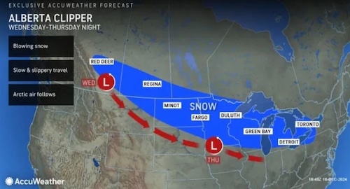
New York’s Staten Island. An oncoming clipper storm from Alberta may intersect with another system out in the Atlantic Ocean this weekend, potentially bringing the season’s first heavy snowfall to New York City.
According to the National Weather Service, a clipper storm is a swift storm that moves from Alberta, Canada, across the Great Lakes and enters the United States.
While there have been a few snowflakes in New York City in recent weeks, previous cold precipitation events have failed to leave any footprints on the ground because of high temperatures.
But if all goes according to plan, the five boroughs might just wake up to a few inches of snow on Saturday.
The formula for snow
There are several potential weather situations for this weekend, according to senior meteorologist Dave Dombek of AccuWeather.
The temperature is the primary variable at work. According to AccuWeather, Friday’s low will be slightly below freezing at 29 degrees, which is good news for people who like the powdery precipitation. With a low of 19 degrees and a high of just 34 degrees, Saturday will continue to be frigid.
Now, Dombek thinks we might see a snow shower, but nothing that would stick, if the clipper comes through with the cold front and no other factors come into play.
According to Dombek, that kind of system could result in a snow shower, several snow showers, or even a short snowfall. It wouldn’t be a big concern, it wouldn’t be a large storm, and it might not even occur. As that passes through, we might only get a few flurries.
The storm setup for the weekend of Friday, December 20, 2024 is displayed in an AccuWeather image. AccuWeather is the source of this.AccuWeather is the source of this.
But there’s a wild card in the mix that might cause more significant snowfall.
According to Dombek, the clipper might try to engage with a low pressure system that is forming in the Atlantic as it swoops down into the Northeast. The secondary system won’t have any impact on New York City if the ocean storm stays far out in the Atlantic. However, Dombek said that the city might see some snow buildup if that system does approach the coast.
According to Dombek, there is a possibility that the clipper will interact with the storm that is growing offshore and bring it closer to the coast.
The combination between the clipper and the offshore storm might bring it as near to the coast as possible, at least for a few hours on Friday night, when there might be some consistent snowfall in and around the city, Dombek continued.
According to Dombek, the city might get anywhere between a coating and two inches of snowfall in this scenario.
Although this outcome is possible, Dombek makes it clear that it is not the most likely one. Residents still have the opportunity to wake up on Saturday to a winter landscape covered in snow.
A chance of rain on Wednesday
A system that is predicted to bring rain to the New York City region on Wednesday will be followed by Friday’s clipper storm.
While rain is expected in downstate New York, this weather storm may bring a few inches of snow to locations north and around the Catskills.
According to Dombek, this system is predicted to bring anything between a third of an inch and half an inch of rainfall, with the majority of its effects occurring in the New York City area late Wednesday into Wednesday night.
more weather stories
-
N.Y. weather: Could we see a white Christmas in 2024? Historical data reveals the odds
-
N.Y. weather: There s a shift in the forecast for month of December
-
Experts update La Ni a forecast: What it could mean for winter
-
N.Y. weather: Here s what early forecast for 1st month of winter shows
Note: Every piece of content is rigorously reviewed by our team of experienced writers and editors to ensure its accuracy. Our writers use credible sources and adhere to strict fact-checking protocols to verify all claims and data before publication. If an error is identified, we promptly correct it and strive for transparency in all updates, feel free to reach out to us via email. We appreciate your trust and support!


+ There are no comments
Add yours