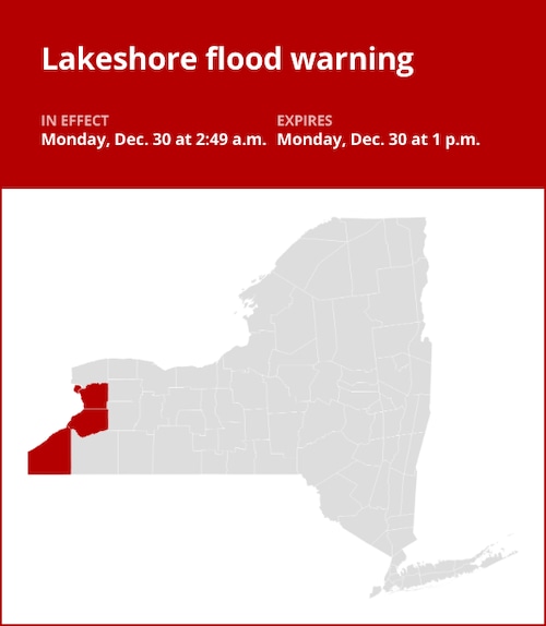
The National Weather Service issued an updated shoreline flood warning for Erie and Chautauqua counties on Monday at 2:49 a.m., which will remain in effect until 1 p.m.
According to the weather service, “Lakeshore flooding expected.”
“Lakeshore flooding will occur along the Lake Erie shoreline due to the swift increase in water levels at the lake’s eastern edge. Route 5 in Hamburg, Buffalo Harbor and Canalside, Dunkirk Harbor, and other flood-prone areas are likely to experience flooding. Significant coastline erosion will also be caused by extremely strong wave action, according to the weather service. “A lakeshore flood warning indicates that there is, will soon be, or is anticipated to be lakefront flooding. Avoid beaches, piers, rock outcroppings, and breakwaters for your own protection! Waves can quickly wash you away and are frequently bigger than they seem. Anticipate severe road closures in the area, substantial beach erosion and debris, and highly hazardous boating conditions.
Deciphering advisories, watches, and warnings: Understanding weather alerts
-
Flash flood warning: Take action!
When a flash flood is either approaching or has already occurred, a warning is given. Moving to higher ground right away is essential in places that are prone to flooding. A flash flood is a quick, intense flood that can form in a matter of minutes to hours and even occur in places that aren’t currently receiving any rain.
-
Flood warning: Take action!
When flooding is about to occur or has already started, a flood warning is issued.
-
Flood advisory: Be aware:
When flooding is not predicted to become severe enough to warrant a warning, a flood advisory is issued. However, it still has the potential to be extremely inconvenient and, if careless, to result in circumstances that endanger life and/or property.
-
Flood watch: Be prepared:
When the weather is conducive to flooding, a flood watch is issued. Although it doesn’t ensure flooding will happen, it does indicate that it is a potential.
Weathering the storm: Flood safety guidelines from the weather service
Floods can be a serious hazard, particularly if you live in a flood-prone location or camp in a low-lying area. The weather service provides crucial flood protection instructions to protect you:
Look for higher ground.
Moving to higher ground is the first line of defense if you live in an area that floods easily or are camping in a low-lying area.
Respect evacuation directives:
Respond quickly to any evacuation orders issued by local authorities. Secure your home by locking it before you leave.
Cut off appliances and utilities:
Disconnect your appliances and utilities if you have the time. By taking this precaution, electrical dangers during flooding are reduced.
Avoid drowned places and flooding basements:
Stay away from rooms with electrical outlets or cords that are submerged in water or basements. Electrical accident prevention is essential.
Quick evacuation to keep you safe:
Evacuate right away if you see sparks or hear popping, crackling, snapping, or buzzing noises. Avoid going into water that might be electrically charged.
Avoid going on foot in floodwaters:
Never try to cross flooding on foot. Six inches of quickly flowing water can knock you off your feet with force.
When stuck, look for higher ground:
If you find yourself caught by flowing water, move to the highest spot you can and dial 911 to reach rescue personnel.
Flooding may occur during periods of intense precipitation, particularly in low-lying and flood-prone locations. Even if the water doesn’t seem deep, you should never drive across it. The weather service claims that most cars can be washed away with just 12 inches of surging water. Be knowledgeable and ready to stay safe.
United Robots offers a service called Advance Local Weather Alerts that gathers the most recent information from the National Weather Service using machine learning.
Note: Every piece of content is rigorously reviewed by our team of experienced writers and editors to ensure its accuracy. Our writers use credible sources and adhere to strict fact-checking protocols to verify all claims and data before publication. If an error is identified, we promptly correct it and strive for transparency in all updates, feel free to reach out to us via email. We appreciate your trust and support!


+ There are no comments
Add yours